Water utilities and other service providers are now in a mandatory compliance phase under the U.S. Environmental Protection Agency’s (EPA) Lead and Copper Rule (LCR). Issued in January 2021 and effective in December that year, the revised LCR gives providers until Oct. 16, 2024, to inventory any potentially hazardous service lines containing lead. The goal is for each provider to have an accurate view of the scope of the problem, to establish potential sampling locations and proactively notify any customers who may be served by lead service lines.
Though these mandates may seem daunting, a number of pathways — including geographical information system (GIS) tools — are available for completing accurate inventories.
Finding What’s Out There
As a first step in creating the inventory, providers may use historical records such as work orders, or may review water samples and testing. They may also conduct field exploration, or some combination of these activities. While we encourage water service providers to start with their historical data to build inventories, it’s likely on-site inspections will be required to determine material types. Utilizing GIS can be valuable not only for the immediate task of building inventories, but also for the long-term needs for communication and management of lead service line replacement programs.
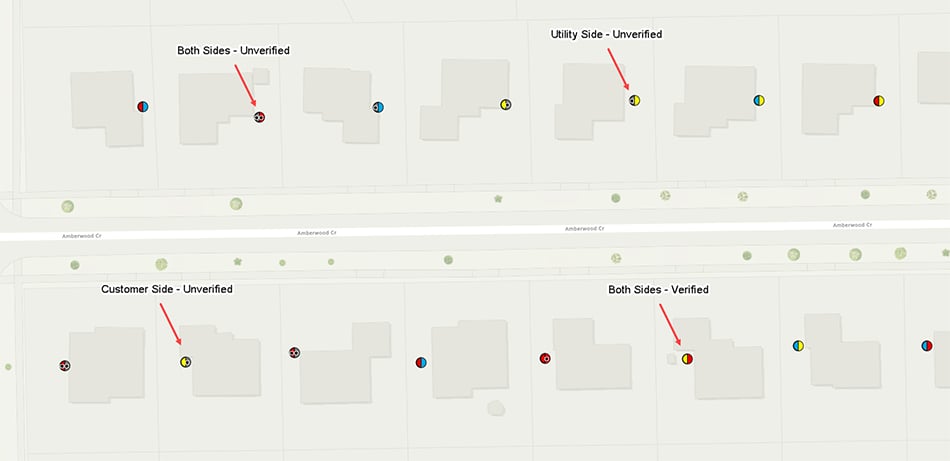 Figure 1: A variety of records may be used to build system inventories.
Here is a high-level guide for setting up an ArcGIS Online organization to capture field inspection information for a lead service line inventory, prioritizing the inventory locations and utilizing an asset management system to complete the inventory requirement by Oct. 16, 2024.
Getting Started
The first step is to utilize your existing ArcGIS Enterprise or Online environment to create the field mobility tools necessary to inventory the service lines. This will be the same platform used to provide the inventory to the public under a requirement for utilities or providers serving more than 50,000 customers. If your organization does not have an ArcGIS Online organization, one can be purchased and set up quickly using the ArcGIS Online website.
When purchasing an ArcGIS Online organization, you will need a Creator-level account to act as the administrator of the environment. Additionally, those collecting field data will need named Field User-level accounts. These named individual accounts can be purchased ahead of time or as needed throughout the inventory.
Leverage Pre-Built Solutions
Esri has developed a Lead Service Line Inventory solution that can be quickly deployed into your ArcGIS environment. Offering prebuilt sets of maps, dashboards and mobile tools, this GIS package can be helpful in getting a head start in field data collection and reporting. By deploying this solution into the ArcGIS Online or ArcGIS Enterprise environments, pre-built sets of maps, dashboards and mobile tools will be available.
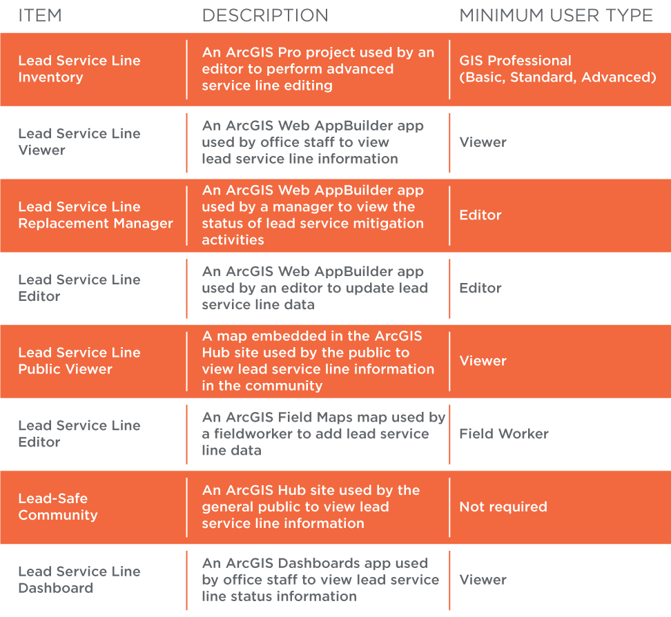 Figure 2. These applications can help meet LCR compliance requirements. Source: Esri
Once installed, the lead service line inventory can be configured and adjusted as needed.
Field Inventory Plan
Because potholing and performing manual inspections can be a costly part of this compliance exercise, a field inventory plan is a necessary next step. GIS functionality can be used to analyze various data sources to better determine where to inspect and prioritize. Analyze a variety of datasets to obtain a better understanding of where lead service lines might be. Use the results to inform your field inventory plan prior to dispatching crews to prioritize locations, subsequently working through the community.
Field crews will utilize mobile GIS solutions to complete the inventory and update their maps, informing relevant stakeholders of the day-to-day progress. This will allow the project team to adjust the field inventory plan in real time. As lead service lines are confirmed, that information will provide insight into the replacement planning process. Locations of confirmed lead lines can be incorporated into the survey location prioritization model, helping to prioritize where to perform future field surveys.
Moving Beyond the Inventory
Meeting inventory requirements is only a portion of the overall rule. Once identified, lead service lines need to be replaced. Utilizing your existing asset management platform in combination with GIS is an effective way to manage individual lead service line replacement projects as well as larger programs.
A computerized maintenance management system (CMMS) allows an organization to leverage the power of GIS while managing workflows and tracking work activities along with the labor and equipment. It will also assist in mapping work orders, work history and crew tasks. Nearly all asset management platforms offer cloud solutions that can link directly with GIS assets. For those utilities or providers that do not have an asset management system, a number of platforms are now widely available. Some of these include: Cityworks, ElementsXS, Cartegraph, and Lucity.
Let’s Get Started
The digital solutions we’ve outlined can be used to tackle the inventory requirements set by the LCR and subsequently used to support actual line replacement activities. By utilizing the ArcGIS Online environment along with some pre-built ArcGIS solutions, utilities can quickly stand up the tools needed to cost-effectively comply with the rule. The task of providing safe drinking water to communities will not be daunting if the right tools and resources are in place.
The EPA estimates there are up to 10 million lead and copper water service lines in place throughout the U.S. By implementing a robust GIS capability, utilities can meet the challenge of identifying and replacing hazardous lead lines.